
Main Weather Station at Archbold Biological Station. Photo by Kevin Main
Author: Kevin Main
Weather data have been collected at Archbold Biological Station for nearly 90 years,” said Kevin Main, Land Manager for Archbold. “We have daily high and low temperature, and daily rainfall going back to 1931. In 1982 additional sensors were added to measure humidity, soil temperatures, and evaporation, and in 2006 we got an automated system that records even more detailed weather data.” The Station currently records 15-minute data for temperature, rainfall, relative humidity, wind speed and direction, soil temperature and moisture (at three depths), barometric pressure, and light intensity. Archbold uses the data in conjunction with the many research projects that require precise information about weather conditions and trends.
“Weather data are also useful during prescribed fires,” Main said. “I can access the data from my smartphone and look at trends in humidity, wind speed and wind direction during the day, which helps me make decisions for managing the fire.”
The Archbold weather station happens to be located in a rather cold spot. “I have received several calls over the years questioning our low temperatures. It can be 5-10 degrees colder at the Archbold weather station than other locations just a few miles away, and it’s not because of a faulty temperature sensor. We have two professional grade sensors on site, and both are always within a degree of each other,” said Main. “The record low recorded at Archbold was 13 degrees Fahrenheit, on January 12, 1982 and January 5, 2001. The temperature has sunk into the teens 23 days in the last 50 years. Snow was recorded for one day, January 19th, 1977, when a “trace” of snow was recorded.
While Florida certainly feels hot in the summer, the actual temperature rarely gets above 100 degrees F. The highest temperature recorded at Archbold in the last 50 years was 103 degrees F, on July 3rd, 1998. The daily high temperature was 100 degrees F, or higher, just 24 times since 1969.
Hurricanes are a big driver of weather during the summer months. The weather station has recorded tropical winds and rain multiple times. The single largest rainfall event was caused by Hurricane How on October 2nd, 1951, when 12.15 inches of rain fell in a one-day period. The most recent hurricane to affect this area was Hurricane Irma, in 2017. Archbold received 8.89 inches of rain over a two-day period and had peak winds of 97 mph (which ended up being one of the highest reliable wind readings on the Florida peninsula during the passing of the storm).
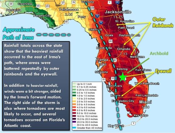
Hurricane Irma’s path across Florida. Archbold received heavy rains
and wind from the eastern eye wall of the storm. Photo credit: National Weather Service
Archbold’s weather data are provided to the National Weather Service through the Service’s Cooperative Observer Program. “We have been an observer station for the National Weather Service since 1969, and we recently received an award from them for 50 years of service,” said Main.
“The Archbold weather data are not currently publicly available online in real time from Archbold, although you can retrieve daily data from the National Weather Service”, says Hilary Swain, Archbold Director. “Data from private weather stations like Archbold can also be viewed on websites such as Weather Underground. Vivienne Sclater, who heads up data management at Archbold, is moving us over to a new data management system in the coming months and that should rectify some of the challenges of making more Archbold monitoring data available to the public in the future.” If you are interested in local weather, there are several other weather stations in this area that provide data. NOAA maintains a very extensive Climate Reference Network (CRN) station on Archbold property a little further south towards Venus with 15-minute data for many meteorological measurements. (https://www.ncdc.noaa.gov/crn/station.htm?stationId=1530). Archbold’s Buck Island Ranch has an extensive network of weather stations and data from the Ranch’s main weather station are streamed to the US Department of Agriculture for posting online. The Florida Agricultural Weather Network (FAWN) is another source of weather data locally, supporting a weather station in Sebring and another in Palmdale (https://fawn.ifas.ufl.edu/) with publically accessible data.
