Do you like to look at old pictures? It can be fun and interesting to see what your parents or grandparents looked like when they were young or maybe what your town looked like before you were born. Sometimes you can learn something about your family and friends that would be difficult to correctly describe with words.
A photo point in 1997 before any disturbance and 70 years fire suppression. Photo by Archbold Biological Station.
“At Archbold Biological Station old photos are very useful guidance tools,” says Kevin Main, Land Manager at Archbold. “We study old photos and sometimes use them to guide management of the property. For instance, old photos from the 1920s and early 1930s of the Red Hill, one of the highest points of Archbold Biological Station at 215 feet elevation, show an open area with scattered shrubbery, grasses and some pine trees. Today most of the Hill is covered with dense shrubs due to the area being fire suppressed for decades. We use the old photos as a guide to restoration and a goal for what we would like the Hill to look like again.”
“Archbold also has an extensive photo point collection,” Main continues. “A photo point is a precise place where you take repeated photos over many years to see how things change over time. In 1992, we chose 200 points across the property to be permanent photo locations. We visit these photo points at about every five years, taking pictures in the same direction and with the same camera settings each time. This way we have documentation of changes in things such as vegetation height. We can also visually see the impact of management activities such as prescribed fire.” Eric Menges, Program Director of the Plant Ecology Program, was one of the first researchers at the Station to recognize the need for a photographic record. “We chose points across the entire property so that we could track landscape scale changes over time,” says Menges. “We have a 25-year record so far, and can already use these to document big changes to vegetation structure in some locations. These pictures will become more valuable as we get out 50 or 100 years.”

The same photo point in 2004 showing the effects of 2004 hurricanes. Photo by Archbold Biological Station.
“The photo point collection is now completely digital,” explains Main. “The first few year’s photos were done using film cameras. In 2004, we started using digital cameras to capture imagery. The old slides were scanned into digital files as well. Now it is easy to access the imagery for any area we need to review.”

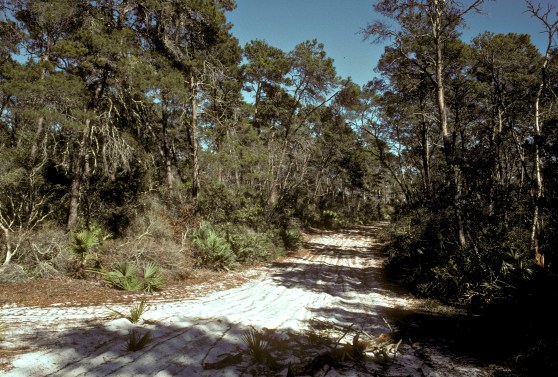
The same photo point in 2015 shows recovery and prescribed fire. Photo by Archbold Biological Station.
Main continues to take photo point pictures each year. “As we added land, the original 200 points have expanded to over 300. And the sky is not the limit,” he quipped, adding “this year we will be adding aerial photo points to the collection. With our new drone we will be able to fly to specific locations at specific altitudes and take pictures, and then return to those same locations year after year for more photos. The technology is really amazing.”
“Today’s pictures will be historic tomorrow,” says Main. “They may not seem significant now, but someday they could have value for reasons we might not think of today. If we keep a careful record, following the same protocol from year to year, we will end up with a tool that can help guide decisions made by future generations.”
